


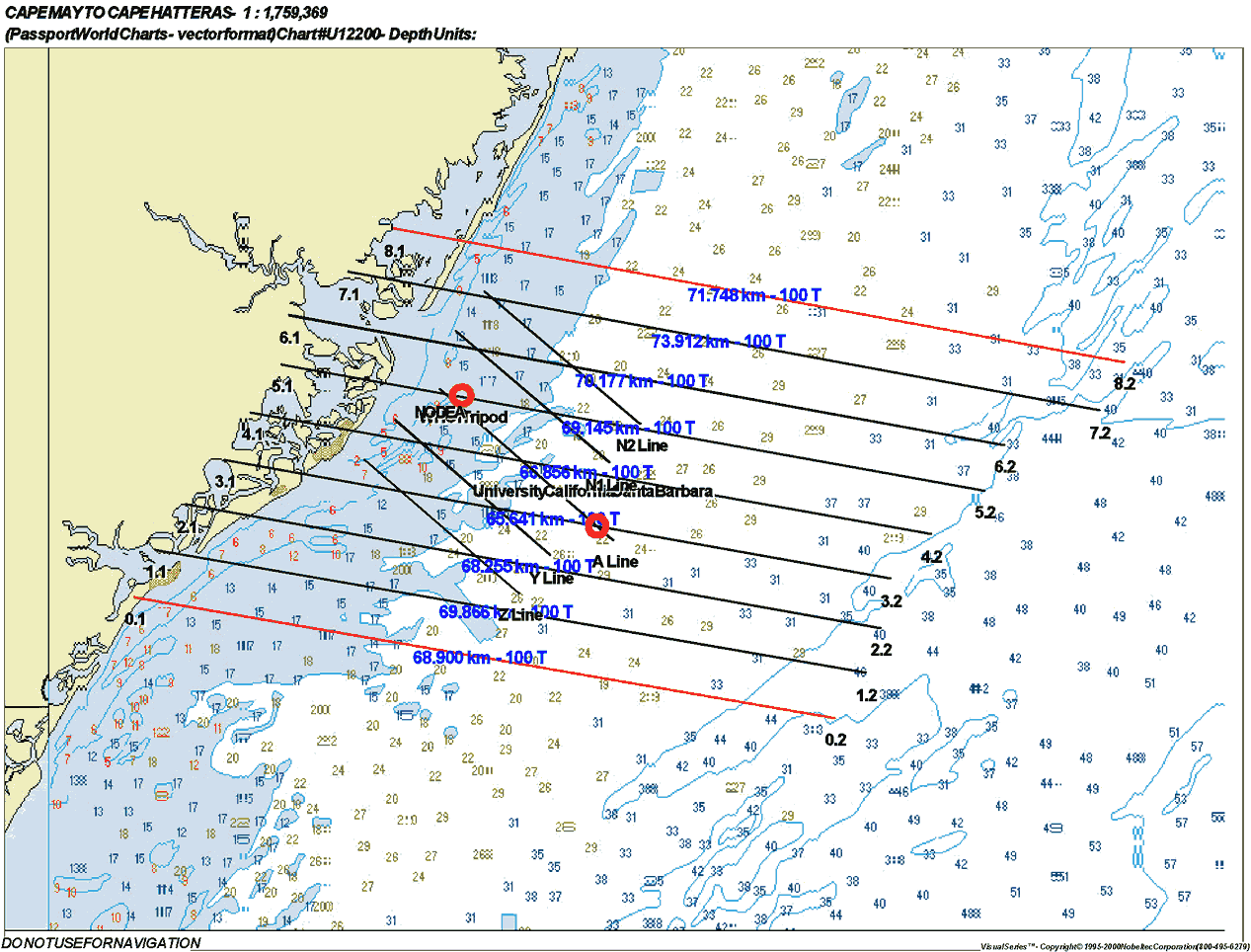
40-Meter AM Flight Lines
(Click on thumbnail for full image)
Station and Turn Times
| Line |
Line Begins
|
Line Ends
|
Zenith Angle
|
Turn Time
|
Direction
|
| Line 6 |
9:00 AM
|
9:07:AM
|
55.25
|
8 minutes
|
W-E
|
| Line 7 |
9:15 AM
|
9:22 AM
|
52.37
|
6 minutes
|
E-W
|
| Line 5 |
9:28 AM
|
9:35 AM
|
49.88
|
6 minutes
|
W-E
|
| Line 3 |
9:41 AM
|
9:48 AM
|
47.41
|
6 minutes
|
E-W
|
| Line 1 |
9:54 AM
|
10:01 AM
|
44.77
|
7 minutes
|
W-E
|
| Line 4 |
10:08 AM
|
10:15 AM
|
42.16
|
6 minutes
|
E-W
|
| Line 2 |
10:21 AM
|
10:28 AM
|
39.96
|
W-E
|
If time permits, Line 0 and Line 8 will be flown after the original 7 lines.
Latitude and Longitude Points
| Line |
Point
|
Latitude
|
Longitude
|
| Line 0 |
0.1
|
39 16.711 N
|
74 36.420 W
|
|
0.2
|
39 10.350 N
|
73 49.027 W
|
|
| Line 1 |
1.1
|
39 19.279 N
|
74 34.979 W
|
|
1.2
|
39 12.796 N
|
73 46.977 W
|
|
| Line 2 |
2.1
|
39 21.728 N
|
74 32.848 W
|
|
2.2
|
39 15.389 N
|
73 45.891 W
|
|
| Line 3 |
3.1
|
39 24.129 N
|
74 30.306 W
|
|
3.2
|
39 18.014 N
|
73 45.125 W
|
|
| Line 4 |
4.1
|
39 26.622 N
|
74 28.423 W
|
|
4.2
|
39 20.371 N
|
73 42.383 W
|
|
| Line 5 |
5.1
|
39 29.087 N
|
74 26.431 W
|
|
5.2
|
39 22.643 N
|
73 38.782 W
|
|
| Line 6 |
6.1
|
39 31.767 N
|
74 25.863 W
|
|
6.2
|
39 25.209 N
|
73 37.477 W
|
|
| Line 7 |
7.1
|
39 33.970 N
|
74 21.922 W
|
|
7.2
|
39 27.072 N
|
73 30.939 W
|
|
| Line 8 |
8.1
|
39 36.284 N
|
74 18.798 W
|
|
8.2
|
39 29.587 N
|
73 29.269 W
|