


40-Meter PM Flight Lines
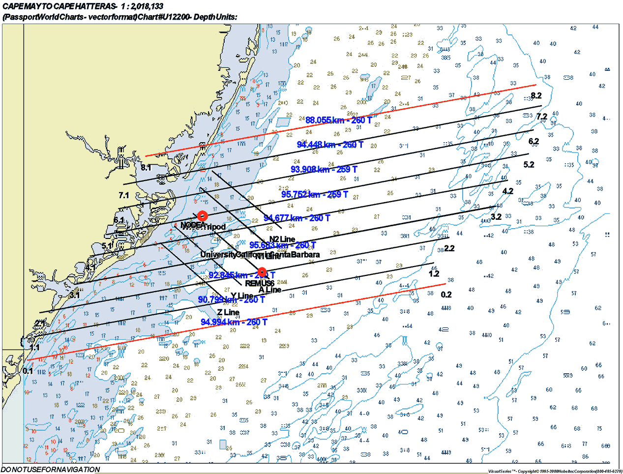
(Click on thumbnail for full image)
Station and Turn Times
| Line |
Line Begins
|
Line Ends
|
Zenith Angle
|
Turn Time
|
Direction
|
| Line 6 |
3:45 PM
|
3:54 PM
|
41.35
|
6 minutes
|
W-E
|
| Line 4 |
4:00 PM
|
4:09 PM
|
44.13
|
6 minutes
|
E-W
|
| Line 2 |
4:15 PM
|
4:24 PM
|
46.96
|
8 minutes
|
W-E
|
| Line 1 |
4:34 PM
|
4:43 PM
|
49.81
|
6 minutes
|
E-W
|
| Line 3 |
4:49 PM
|
4:58 PM
|
52.88
|
6 minutes
|
W-E
|
| Line 5 |
5:04 PM
|
5:13 PM
|
55.77
|
6 minutes
|
E-W
|
| Line 7 |
5:19 PM
|
5:28 PM
|
58.66
|
W-E
|
If time permits, Line 0 and Line 8 will be flown after the original 7 lines.
Latitude and Longitude Points
| Line |
Point
|
Latitude
|
Longitude
|
| Line 0 |
0.1
|
39 10.017 N
|
74 41.800 W
|
|
0.2
|
39 19.244 N
|
73 36.529 W
|
|
| Line 1 |
1.1
|
39 12.918 N
|
74 40.715 W
|
|
1.2
|
39 21.747 N
|
73 38.269 W
|
|
| Line 2 |
2.1
|
39 15.762 N
|
74 39.873 W
|
|
2.2
|
39 24.808 N
|
73 36.005 W
|
|
| Line 3 |
3.1
|
39 19.238 N
|
74 34.503 W
|
|
3.2
|
39 28.610 N
|
73 28.590 W
|
|
| Line 4 |
4.1
|
39 22.341 N
|
74 31.934 W
|
|
4.2
|
39 31.658 N
|
73 26.612 W
|
|
| Line 5 |
5.1
|
39 25.414 N
|
74 29.515 W
|
|
5.2
|
39 34.846 N
|
73 23.558 W
|
|
| Line 6 |
6.1
|
39 28.443 N
|
74 27.552 W
|
|
6.2
|
39 37.699 N
|
73 22.823 W
|
|
| Line 7 |
7.1
|
39 31.304 N
|
74 26.775 W
|
|
7.2
|
39 40.614 N
|
73 21.599 W
|
|
| Line 8 |
8.1
|
39 34.602 N
|
74 23.011 W
|
|
8.2
|
39 43.265 N
|
73 22.163 W
|